
Overview
When a top five gas pipeline company sought opportunities to replace retiring coal plants with gas generation their key evaluation factors included proximity to corporate and market infrastructure. But the company lacked the time, tools and technical expertise to conduct the required geographic research, so they enlisted Arbo’s team of data scientists and industry experts for support on this strategic growth project.
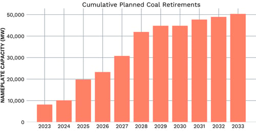
Coal retirements are intensifying the need for natural gas as a base-load generator, and the integration of renewables into the grid is also increasing peak demand for natural gas.
The Problem
Our customer envisioned new opportunities to build gas infrastructure in the expanding market for cleaner and more efficient energy sources. With over 100 coal plants planned for retirement in the next decade, facilities closest to their pipeline footprint and existing gas delivery infrastructure would have the highest potential value and allow for optimized resource allocation. Their challenge was to find, acquire, structure, and interpret the data on these retiring plants and any renewable or gas generation projects already in the planning phase. It was important for analysis that the data to be overlayed geographically, and their digital mapping capabilities were limited, so the team engaged Arbo to assemble a cohesive story that could be understood, visualized, and ultimately leveraged for data-driven decision making in the c-suite.
The Solution
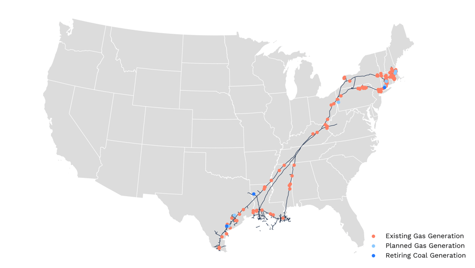
The Arbo team leveraged its data acquisition engine and advanced analytics capabilities to seamlessly integrate diverse datasets from multiple disparate sources, extract and normalize the relevant geospatial information — lat/long data, addresses, points, lines, and polygons — and programmatically transform those with proprietary code into locations, paths, and areas on a map. The deliverable overlay looked similar to the below sample, including:
- Locations of retiring coal plants in relation to the customer’s assets
- Map of existing and planned energy infrastructure
- Various regional snapshots
The customer was thereby able to visualize the location of retiring coal generation and existing or planned gas and renewable generation infrastructure — illuminating the landscape of commercial prospects for the strategy team and leadership.
Arbo’s mapping capabilities are highly sought by strategy teams gathering intelligence on supply and demand changes in proximity to existing asset footprints.
The Impact
Without the support of ArboIQ, this customer would have invested a considerable amount of time manually researching, compiling, normalizing, and structuring diverse data points — an effort which may not have completely captured the breadth of the opportunity landscape.
Prudently, they trusted in Arbo’s data science and subject matter expertise to expedite this process and achieve the highest quality and most customized result — holistic asset intelligence for decision analysis.
In a matter of days, the customer had a set of maps and reports to distribute to the broader commercial team. To date, the company has had eight new compressor station projects certificated or placed in service.